Tuesday, 14 June 2016
Sunrise 0507, Sunset 2018
LW 1146, HW 1636
Sunny, 77(F), 41% Humidity
1010 hPa
Winds NNW 10-15 kts, gusting 25 knots
Waves 2-3 feet
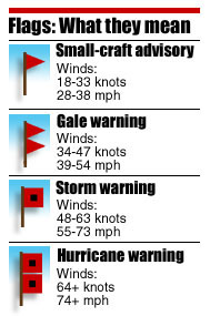
SMALL CRAFT ADVISORY
Depart 1010, Arrive 2015
36.2nm, 10hr 5min
Eager to sail. Not two-hour spin-around-the-parking-lot sailing, but some destination sailing. I've been giving some thought to getting started with a couple of overnight trips, to Hadley Harbor near Woods Hole, to Cuttyhunk, even to Martha's Vineyard. The Kalmar Nyckel will be in Provincetown in late July, and I have even given some thought to sailing there, across Cape Cod Bay, to meet up with my old shipmates. One day, I want to do the Figawi and sail to Nantucket. But that is an over-the-horizon sail and perhaps I need a bigger boat. I would also like to sail up the east coast of Massachusetts, to Boston, Cape Ann, and points north, maybe even spending a few weeks (or will it take months?) tooling around the coast of Maine. Then, of course, there is the Intra-Coastal Waterway (ICW). I would like to travel down "The Ditch" to Savannah one year in the future, making may way to the waterfront home of my wife's friend for some fresh roasted oysters. Small boat, big dreams.

Mid-Atlantic Section of the Intra-Coastal Waterway.
The entire 3000 mile (largely inland) route runs from Boston, MA, to Brownsville, TX
"One day, lad, all this will be yours...."
Crawl, Walk, Run. But let's not put the dinghy before the sloop. Best to start with some longer full day sails, I figured. So I came up with this zany idea to do a day sail to Cuttyhunk and back. That's at a rhumb line of at least 20nm, and a sail track upwards of 25-30nm (each way), depending on course. I figured if I could average 3.5 knots, I might make it to Cuttyhunk and back in 17-18 hours. If I left at the crack of dawn, I should be home by midnight. That was my Id talking; before long, my Superego got the better of him. That was a dumb plan.

Buzzards Bay
Monday, June 13th, there was a Gale Warning posted, so my sailing plans were put on hold. The next day, however, the winds were forecast to moderate a bit. My original plan was to get up at 0400 and get an early start, but I slept too late. Then I discovered that the winds were still pretty strong -- when you have to fight white cap waves and spindrift on the river as you row the dinghy out to the sailboat, then you know it is still blowing out there on the bay. There was a Small Craft Advisory up.

A little rough-looking even inside the shelter of Dexter's Cove....
I was still determined to go out for a long sail. Given the winds were blowing offshore, out of the north, I figured if I stayed relatively close in to the south coast then it should be a little less rough than out in the middle of Buzzards Bay. My revised sail plan was to head down as far as New Bedford or Padanaram and then return. All the same, considering that I was again sailing alone, I decided that with a SCA posted it was prudent to go with a reefed main sail. If winds were manageable, I would unfurl the jib too.

Sail Plan
This was also a good opportunity to test out a new app, "RaceJoy," that tracks one's position and progress through a race or training exercise. Use of this app as a new safety requirement has been mandated by the organizers of the annual "Blackburn Challenge," a 20+ mile circumnavigation of Cape Ann and a big rowing event in New England every summer. My whaleboat team, the "Polar Oartex," is currently training for this year's race on July 16. The app allows spectator-users to see a visual display of a participant-user's position on a map. It has an option to allow tracking during "training" sessions, so I convinced the Admiral to download the app and see whether she could follow my position throughout the day's sail.

The User Interface is not ideal, and some of the control settings are not all that intuitive,
but it does work....
I went aboard at 0935 and stowed my victuals for the day sail: water, a couple of Diet Cokes, a ham and swiss sandwich, and two Braeburn apples. I also affixed to the stern rail a small video cam in a waterproof case: a DBPower SJ4000 (Go-Pro knock-off) that my kids bought me for my birthday. It takes some decent quality video, but unfortunately the battery died before I got out to the more exciting parts of the day's sail. Then I set about reefing the main. On the plus-side, this meant I did not have to struggle hoisting the sail the last few inches to the top of the mast; on the minus-side, the sail is not taut when reefed, as can be seen in the photo below: there is some slack near the tack that I have not yet figured out how to remove.

Main sail reefed. Note the zip-ties I put on the spreaders to deter birds....
Finally, I got underway at 1010. The wind was blowing a good 16 knots, as measured from the cockpit with my handheld anemometer. Every ten or fifteen minutes a strong gust of 25 knots or more would come blowing out of the north, the telltale surface ripples to windward signaling its impending arrival, and heel the boat over. By 1120, I had raised Bird Island on my starboard bow, and the boat was making four to five knots on a starboard tack. Eager for more, I let out half of the jib. Captain Bob warned me that unfurling only half the jib was bad for the sail, but I just wasn't sure how the boat would handle (or how I would handle) in these winds with the jib fully deployed.
Here's a video clip of 'Piao' underway off Mattapoisett
This put me up to five-and-a-half to six knots. Nice. At 1304, the Admiral sent me a text message: "Wow! You are off West Island." So, I guess the RaceJoy app works reasonably well (it is, however, a huge drain on the battery, requiring continuous 'Background App Refresh'). An hour later I was past Clarks Point and approaching Padanaram. With the famous "Dumpling Rocks" off Round Hill clearly visible ahead to the south, I started thinking about turning for home. At 1420, at Bents Ledge, I turned NE and put her on a port tack, rounding back towards Fort Rodman (Fort Tabor) on Clarks Point. I had traveled about 18nm in four hours, averaging about 4.5 knots.

My turn-around point at Bents Ledge (Red #6) off Padanaram.
You can also see my short tacks to the NE on the return leg,
as I worked my way up and around Butler Flats Light.
as I worked my way up and around Butler Flats Light.
Before heading home, however, I wanted to sail around Butler Flats Light. My whaleboat team often rows out to this abandoned lighthouse in the outer harbor of New Bedford at the mouth of the Acushnet River. I could not reach it on my outbound leg: the northerly winds were just too strong and I could not tack upwind sharply enough to reach the light. Now, however, using the lee of Clarks Point to shelter a bit from the sharp winds, I did a couple of short tacks that, by 1530, brought me up and around the lighthouse. It felt good to see an "old friend," and satisfying to accomplished this goal.

Butler Flats Light, near Clarks Point outside New Bedford
Built in 1898, this is a 53-foot high brick and cast iron "spark plug" style lighthouse that warned ships of a shallow shoal near Fort Taber. It has four levels, including a basement and three levels of living space, each fifteen feet high and thirty-seven feet across, and two watch decks atop the light. Erected on a muddy bottom, a 35-foot iron cylinder was filled with concrete and lowered to the river bottom to provide the foundation for the structure. It had only two keepers, Amos Baker and his son, from 1898 until the USCG took over operations in 1941. It was automated in 1978, and placed on the National Register of Historical Places in 1987. Twice in recent years it has gone up for auction. In 2013, the high bid of $20,000 was rejected as insufficient (Bidders that year were unable to land on the lighthouse due to a broken ladder; one of them, a man from Virginia, said he blamed Obama for that, of course). It sold for $80,000 in a new auction in 2015. Some members of our whaleboat rowing club would like to acquire the structure for use as our clubhouse, and sell pizza and cold beverages to passing boaters. You can read more about Butler Flats Light here: http://www.lighthousefriends.com/light.asp?ID=619; and here: http://www.us-lighthouses.com/displaypage.php?LightID=420; some interesting interior photographs may be found here: http://www.lighthousedigest.com/digest/StoryPage.cfm?StoryKey=3768

F/V Hannah Boden visiting New Bedford
Sister ship of the 'Andrea Gail' (lost in the "Perfect Storm")
There was quite a bit of fishing vessel traffic departing New Bedford that afternoon. I saw almost a dozen trawlers and scallopers come out of the hurricane barrier and drive out into the Bay while I was in the area. I had to time my crossing of the harbor entrance channel carefully to stay well out of their way. I could see Cuttyhunk, away in the distance. There was no way I would be making it there and back in a single day. That was just a brain fart.

Cuttyhunk on the SW horizon. Maybe next time, but it will definitely be an overnight trip....
On my return leg, I sailed by Angelica Rock and Black Rock off Wilbur Point on Sconticut Neck. We have rowed out here from New Bedford harbor, too. The former is a white rock covered in birds and bird shit -- you could hear them from some distance off; the latter is, well, a black rock.


The aptly named "Black Rock" in the foreground with the red day beacon.
Angelica Rock lies behind it to the east.
By 1600 I had made Wilbur Point and turned eastward on a broad reach. But now the wind died. It was sudden, like turning off a light switch. One minute it was blowing 12-15 knots out of the North, the next only 2.3 knots from the SSW. It was a long run back towards Marion. Along the way, off West Island, I grew lax in my watch and negligent with my navigation and almost ran aground on a shoal off Rocky Point, where the bottom rises up to only 1.5 feet!

That was close!
With the wind so weak, it seemed to take forever to put West Island behind me. Everytime I looked towards the shore, there was that black-and-white watch tower still hovering there. It wasn't until 1800 that I reached Mattapoisett. Ten minutes later, off a local shoal called the "Bow Bells," an unexpected shift and gust in the wind, from SWxW to SExE, and from 4 knots to 12 knots, sent the boom flying across the cockpit in an unanticipated gybe.

Sailing homeward on a beam reach in 3-foot following seas....
It took me another hour to pass Bird Island, off Marion's Sippican Harbor. There had not been much traffic on Buzzards Bay that day, but here I was overtaken by a large blue-water sailboat whom, it turned out, was heading towards an overnight anchorage in Wings Cove. He waved. Sailboaters are a friendly sort, even towards us little guys.

He beat me, but he was motoring....
By the time I was off Piney Point, the wind dropped again to less than two knots and only diminished from there. It seemed like the wind was done for the day, and I was getting pretty well done too. At 1910, off Wings Cove, I gave up trying to sail and started the motor. When I finally rounded Great Hill, and turned north towards the mouth of the Weweantic River, I was pretty tired.

Last leg, motoring up to the mooring....
I finally reached the mooring at 8:15pm, a trip of over 36nm that lasted more than ten hours. It was a beautiful end to the day, but I could just tell that it was going to be a "Dark and Stormy" night.

Very Informative Article must visit Gym Leggings For Women
ReplyDeleteAwesome Article Must Visit here: Makeup Accessories
ReplyDelete